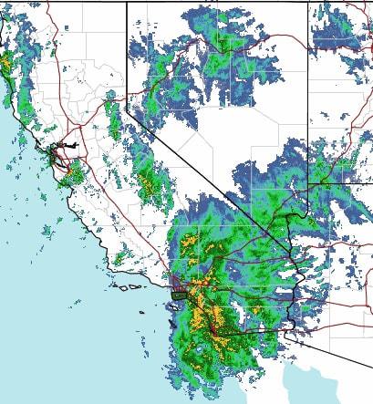
As projected by the National Weather Service (NWS), the vast majority of precipitation fell in Santa Monica between 4 a.m. and 10 a.m. Thursday. According to the NWS’ observation station at the Santa Monica Municipal Airport (SMO), a total of 1.2 inches of rain inundated the city from 4:24 a.m. to 9:51 a.m. Before the main storm, 0.25 inches fell in the early overnight hours, making for a total of 1.45 inches through the duration of the storm.
Though a smattering of rain was scheduled for Thursday afternoon, most of the storm moved through the Los Angeles County area at or before 10 a.m., save for some heavier precipitation on the eastern end of the county. Santa Monica was put under a Flood Advisory and Wind Advisory by the NWS through 11 a.m. Thursday, with a High Surf Advisory still intact through Saturday morning.
The Santa Monica station reported less rain than local contemporaries, with 12-hour totals at observation stations in Venice (2.05 inches), Brentwood (2.17 inches) eclipsing the Santa Monica total. Pacific Palisades was the most impacted local area, drenched with 2.79 inches of rain over the 12-hour period from Wednesday evening through Thursday morning.
Much of the worst rainfall impacting California avoided the southern portion of the state, as 3-5 inches of rain permeated throughout Northern California. Along with flash flooding, wind gusts topped 70 mph, taking down trees along the way. Sonoma County in particular was busy with emergency responses, as first responders dealt with water rescues as well as downed power lines. Locally, the Santa Monica Police Department reported no significant uptick in calls for service. Lieutenant Erika Aklufi did note that the department “generally see[s] an uptick in audible burglar alarms when it is raining,” but that the “vast majority of these alarm calls check okay.”
Accompanying the storm were gusty winds, with peak gusts in Santa Monica fluctuating in the high teens and low 20s throughout. The highest peak gust recorded by the NWS station was 22 mph during the 7 a.m. hour.

Credit: National Weather Service
Traffic was impacted during the Thursday morning commute, as Caltrans District 7 announced on social media that all southbound Pacific Coast Highway lanes were closed at the McClure Tunnel due to flooding at 7:30 a.m. Vehicles were diverted off onto Oceanview Ave., and maintenance was on scene throughout the morning. All lanes reopened at around 10:50 a.m.
Air travel in the area was only mildly affected, with zero delays or cancellations of flights noted at SMO, per flight tracking service FlightAware. The service’s report on Los Angeles International Airport (LAX) states that five flights originating at the airport Thursday morning were canceled, and 72 flights were delayed. Flights with LAX as a destination were canceled seven times and delayed 54 times.
The area isn’t close to out of the woods, however, as an even stronger storm is poised to start late Saturday evening into Sunday. The NWS calls this the “largest storm of the season” for Los Angeles, producing at least 24 to 36 hours of “continuous rain.” Early NWS estimates call for rain amounts between 2-4 inches from Sunday to Wednesday, with the heaviest portion of the storm coming down Sunday night into Monday.
Much like the Thursday storm, the upcoming inundation is due to an atmospheric river, with the second noted as slower-moving than the first. According to AccuWeather Senior Meteorologist Day Pydynowski, the storm has originated from near Hawaii “and is likely to have a true plume of tropical moisture associated with it.”
Hazards associated with the upcoming storm include rock and mudslides, flooding of small streams and rivers, as well as rises to some of the area’s larger rivers and streams.
thomas@smdp.com


