 MATTHEW HALL
Daily Press Editor
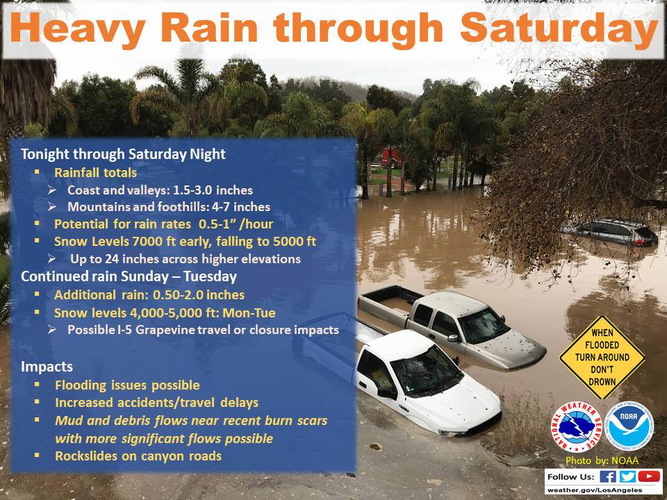
A powerful storm heading toward California is expected to produce heavy rainfall, damaging winds, localized stream flooding and heavy snow in the Sierra Nevada.
Forecasters say rain will arrive in the north late Friday afternoon and reach the south late in the night, and last through Saturday night.
The first storm moved through the region Thursday bringing up to 2.5 inches of rain to areas of Southern California. The next bout of rain is expected to be heavier and last longer. According to the National Weather Service, rainfall could reach 1.25 inches per hour on south facing foothills and coastal slopes. Forecasters said they predicted up to 7 inches of rain to fall through Saturday.
“During times of heavier rainfall, there will be the potential for flooding of small streams and creeks, along with significant water flows in rivers which will increase the threat of swift water rescues,” said the National Weather Service’s local prediction. “Traveling across roadways will become more treacherous as roadway flooding will likely become more significant and widespread, along with an increased threat of rockslides and mudslides in canyon roadways. For the recent burn areas, shallow mud and debris flows will be likely, with the potential for more significant and damaging debris flows if rainfall rates over one inch per hour develop. A Flash Flood Watch will likely be issued for the recent burn areas as we draw closer to the event.”
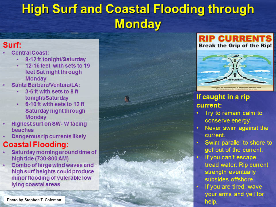
In addition to the flood warning, the NWS issued a Beach Hazard statement through Monday morning due to elevated surf and dangerous rip currents.
“Elevated surf of 3 to 6 feet with local sets to 7 feet is expected late tonight through Saturday evening,” said the warning. “Surf may build to 6 to 10 feet with sets to 12 feet on west facing beaches late Saturday night and Sunday, and a high surf may be needed at that time. Surf will subside slowly Sunday night and early Monday.”
Forecasters said flooding is possible in some areas and there will be wind driven waves along the coast.
“The combination of wind waves and high surf may result in minor coastal flooding of low lying areas such as beach parking lots and harbor walkways near south facing beaches Saturday, and west facing beaches Sunday,” said the warning. “This is mainly a threat within a couple of hours on either side of the morning high tides Saturday and Sunday, which are between 7:30 and 8 a.m.”
The NWS said Southern California residents, in or below the recently burned areas, such as the Woolsey Fire Scar, are urged to take the steps necessary to protect their property. Officials said Persons in the watch area should remain alert and follow directions of emergency preparedness officials.
“Shallow mud and debris flows are likely across the recent burn areas,” said the alert. “There is the potential for more significant and damaging debris flows. There will also be an increased threat of rockslides and mudslides which could produce road closures.”
Malibu officials said anyone in the burn area should be prepared to evacuate if flooding and mudslides cause problems. They said power outages could hinder emergency alert systems and locals should leave early if heavy rains persist.
“As part of its storm preparation plan, the City monitors storm conditions, and crews are patrolling and clearing roads of rocks and debris, clearing storm drains and culverts to prevent flooding, placing temporarily concrete k-rails as needed to prevent flooding and debris flows, and has heavy equipment staged at areas sensitive to flooding and debris flows,” said Malibu Media Information Officer Matt Myerhoff. “Sheriff’s Volunteers on Patrol (VOP) will assist with patrolling City streets and reporting issues.”
He said residents should be aware of their surroundings.
“Stay away from flood control channels, catch basins, canyons and natural waterways, which are susceptible to flooding during periods of heavy rain,” he said. “Check on your neighbors, particularly those who are elderly or live alone. People who live on gated properties should leave gates open to prevent mud and debris from locking them in, and to ensure access for emergency responders. Move trashcans and cars off the street to help prevent flooding.”
The City of Malibu has updated a series of online maps showing potential flood dangers and additional storm information is available via their website.
For additional information visit
National Weather Service Storm Information and Forecasts:
https://www.weather.gov/lox
View Post-Fire Flood Risk & Vulnerability Maps:
https://www.malibucity.org/924/Flood-Vulnerability-Maps
More storm preparation information:
https://www.malibucity.org/905/Storm-Prep
LA County Storm Preparation Resource:
Visit www.lacounty.gov/larain for storm season emergency resources, including LA County’s Homeowners Guide to Flood, Debris and Erosion Control.


